mowing the lawn so we can play grass-court bike polo. with five mowers, it only took thirty minutes.


2009-08-14
Calgary Parks Bike Ranger program

Leslie Nicholls (L) and Darrell Howard (R) of the City of Calgary unfurl a banner for Calgary Parks' Bike Ranger program, during the recent CAN-BIKE 2 training course in Calgary.

2009-07-15
Hell on the Horizon

Impressive prairie sky shot by my former work colleague Vincent Potriowski. Programmer by day, photog by night (and, well, weekends).
2009-06-29
2008-08-25
Mobile GPS tracklogs and photo geotagging with the Nokia N82
I've got to say that Nokia's Sport Tracker application running on the GPS-enabled Nokia N82 phone is pretty slick. It doesn't get any easier than this!
Before today's lunchtime run, I started the app, waited a few seconds for a GPS fix, then pressed the Start button. Then I put the phone in my pocket (after locking the keypad, of course). Half-way during the run, our group stopped for a photo, which I took with the phone's 5 MPx camera. At the end of the run, I pressed the Stop button, then "Upload to service". The app asked me if I wanted to upload any associated photos along with the details of my run. When I said 'sure', it searched my phone's memory and found the pictures taken during the run. It geotagged them (marked them with the latitude and longitude where they were taken), then uploaded them to Nokia's special server for Sport Tracker activities. You can see my activity here:
http://sportstracker.nokia.com/nts/workoutdetail/index.do?id=384415
Naturally this requires you to have a data plan with your cellular provider. I'm taking advantage of Rogers' offer of 6 GB for $30/month.
Before today's lunchtime run, I started the app, waited a few seconds for a GPS fix, then pressed the Start button. Then I put the phone in my pocket (after locking the keypad, of course). Half-way during the run, our group stopped for a photo, which I took with the phone's 5 MPx camera. At the end of the run, I pressed the Stop button, then "Upload to service". The app asked me if I wanted to upload any associated photos along with the details of my run. When I said 'sure', it searched my phone's memory and found the pictures taken during the run. It geotagged them (marked them with the latitude and longitude where they were taken), then uploaded them to Nokia's special server for Sport Tracker activities. You can see my activity here:
http://sportstracker.nokia.com/nts/workoutdetail/index.do?id=384415
Naturally this requires you to have a data plan with your cellular provider. I'm taking advantage of Rogers' offer of 6 GB for $30/month.
2008-08-02
Bicycles in Beijing
I had the (mis)fortune to spend a week in Beijing recently, and have a few pictures to share. I say "mis-" because I was just getting over two bouts of pneumonia when I went to Beijing, and something in the air or on the airplane flight home gave me a serious flu which threatened to bring back the pneumonia. But let's focus on the city (map at end of this post) ...
 The new Terminal 3 at Beijing International airport is now by itself the largest airport in Asia, as well as the newest. After registering with the Immigration authorities -- who you are invited to grade on their customer service! -- you are quickly whisked to Terminal 1 in an automated train that takes only a few minutes (compared to up 45 minutes of hell for the same process at London's Heathrow airport).
You may see a few, or more likely, a lot, of these fellows if you are arriving during the Olympics.
Speaking of the Olympics, traditionally, synchronized swimming is a women-only event at the Olympics. But the Beijing airport police have a strong contender for a new event - synchronized walking.
 Once through Customs, you are free to head off on your way to Beijing. I was lucky to be met by the office manager of my employer's Beijing office, and took a taxi to town, but otherwise you can just walk over to the Airport Express train station, location on the roof of the parking garage (which itself has a field of crops growing on its roof). By the way, this picture was taken on a sunny day from my departing aircraft - that's smog, not fog, in the background. The train station is the silver teardrop in the centre of the circular parking garage.
 The train runs on an elevated track all the way to the city, paralleling the airport expressway. In the photo at left you're getting your first glimpses of the city through the smog: lots of apartment buildings and some stylish garden work in the cloverleafs. (That's the 4th Ring Road in the background).
The train eventually dips underground for the final few kilometres to the station. Here's what that part looks like:
 After I got in to town, I checked in at my hotel, got my room, and gazed upon the bridge where Dongsishitiao Road (E-W) crosses over the 2nd Ring Road (N-S). Pedestrians, bicyles, tricycles, scooter, cars, trucks and buses all seem to negotiate this roundabout without apparent anguish. Friday rush-hour traffic.
 Next morning, I took another look. The traffic was quieter, but the air quality no better: that apartment building disappearing in the smog up the 2nd Ring Road is less than 1 km away.
 After an over-priced breakfast in my hotel, I stepped out the door and into the subway. Gulp - my first solo adventure in a country where I don't speak more than 3 words of the language. I confess I felt a little appre-hensive. At the ticket counter, I realised I didn't know how to say "Do you have any all-day tickets?", or even "I'll have one ticket, please", or even "one", or "please". All I could do was hold up one finger, to which the agent replied by holding up 2 fingers. Right, I need to pay him 2 Ren Min Bi (about $0.30). I got on the No. 2 line (dark blue) northbound, then transferred to the No. 13 line (yellow) northbound. After one more stop, I got out and started walking. My destination: a Dahon folding-bike store.
 Lucky for me, I found the store without too much difficulty. And even luckier, they could speak a few words of English. Pretty soon, we had most of their stock out on the sidewalk. I felt like Goldilocks trying one that was too big, another one (the pink one) that was too small, then a final one (silver, behind the red one) that was just right. The price: $200. It's a Prestolite with 16" wheels (more portable than the 20" model I already own). At a local clothing market I found a good carry-bag for it for about $15. I was all set to go exploring!
 After a couple of hours of aimless wandering around, just enjoying the new sights, sounds, smells and sensations, I found myself at the north gate of the Forbidden City. It didn't look like I could take my bike inside, so I rode around to the east gate and walked in there with it. Because the folding bike is so small (and probably because I'm a foreigner) I got away with this. I followed the crowd and eventually emerged out the south door of Forbidden City and then the south door of Chairman Mao's tomb.
 Here I wanted to take a picture of the portrait of the great leader but a policeman told me to "keep walking" and "no pictures". Finally, 100m down the sidewalk, I was able to turn around and take a picture of the building. Next, it was time to investigate the very large open space across the road: Tian An Men Square.
 At the exit of the underground passageway that crosses the busy thoroughfare, from Mao's Tomb to the square, police officers wouldn't let me take my bike into the square. But after I folded it and stowed it in its bag, I was able to walk right in. The square indeed does seem like it truly is the world's largest public square. I made my way to a famous local statue, the monument to the people's heroes. A local resident gestured that he wanted to have his photo taken with me in front of this statue. Individuals are always welcoming; governments less so. The Chinese government in particular doesn't want its citizens to remember the massacre of June 4th, 1989 in this very square, but I felt the history like a weight on my shoulders as I slowly crossed the enormous space.
 Time for some retail therapy! I rode over to Wangfujing Street, supposedly the shopping street of Beijing. It was jammed with shoppers, or at least pedestrians, as it's a car-free mall for a couple of blocks. It was bike-free, too, so I rode around the block to the far end, then continued on north.
 I went looking for the Lama Temple, and crossed through a neighbourhood of narrow streets, called Hutongs in Mandarin (not to be confused with the Cantonese that people from Hong Kong speak). Apparently much of Chinese traditional life takes place in the residences that line these hutongs or the side-alleys. I had vivid memories of this topography from the night that I watched the movie 'Beijing Bicycle' while in Rio de Janeiro Brazil. You can watch a trailer for the movie below.
The Lama Temple was closed unfortunately, so I returned home and planned to try again the next day.
Sunday: one more day before I change from tourist to business person. I got up early and rode up to the Lama Temple, or Yonghegong, and paid the modest fee to enter. I was greatly honoured to be able to spend a couple of hours contemplating the buildings, originally a royal palace but turned into a Buddhist lamasery in 1744. I was somewhat surprised at how many Chinese-looking people seemed to be paying devotional respects by burning incense and kneeling (always three times). Inside the buildings were a variety of religious statues, including in the largest building an 26m-tall Maitreya Buddha statue carved from a single block of rosewood (and thus, the plaque says, holder of a Guinness Record). The pictures below don't begin to capture all of the rich visual tapestry of colours and forms that inhabit this place.


incense offering; Buddhist symbology on rooftop


prayer wheel; guardian demon
Near the Lama Temple by chance I came across the Guozijiang Hutong, which apparently is Beijing's only ancient-architecture street, dating back at least 500 years. I found a temple to Confucius which I didn't have time to visit, and the Xu Xiang Zhai vegeterian restaurant -- Beijing's first -- where I returned to dine that evening.
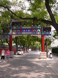

Guozijiang Street; Hutong alleyway
During my work-week in Beijing, I continued to ride my bike, commuting with a few of the millions doing the same. I got a chance to appreciate some of the impressive office buildings that have gone up in recent years -- a testament to the vast inflows of capital to the country. Many of these buildings display an innovative and intriguing architectural style, leading to embarrassment over the beige rectangular boxes that pass for design in downtown Calgary.


CCTV network headquarters; random office complex
So, what's it like to travel around Beijing by bicycle? Fairly relaxing, actually. Most of the major roads have separate bike-only frontage lanes, while the lesser roads have painted bike lanes -- though these can be a bit tricky when buses decide to pull into and stop. In addition you have to cope with some cyclists travelling the wrong way (probably to avoid having to cross the road for just a block or two). At the intersections, things get a little trickier yet, but the best advice seems to be: ride as slowly as the locals, because you have time to adjust to everything that's coming at you. If you try to ride as fast as most North Americans do, you'll find that problems crop up much more quickly -- as can be seen in the video below.
And here's a video I took along one of those separate bike laneways:
One night while riding near the Buy Now Hui electronics market I heard music coming from a parking lot and stopped to investigate. A number of elderly women were performing a traditional dance, while several musicians provided appropriate music for the dancers. Young people passed by without paying any attention (in many cases talking on cell phones) but I was fascinating and stayed quite a while. If I hadn't been riding a bike, I would have missed this cultural moment.
The remainder of my week was spent working in the nearby Langfang City, just a baby of 3-4 Million, and where the air quality wasn't any better.
On my final morning in Beijing, I started with breakfast with an American friend, Bill Hardy, who by wild coincidence just happened to be in Beijing and staying in my hotel, then went for a ride out to Chaoyang Park and amongst other things saw two examples of the breadth of experience available in this city caught between the old and the new:


Brand-new Apple store in San Li Tun; women practicing Tai Chi in Chaoyang Park
If you haven't been to Beijing, give it a thought. It truly is a world-class city and has lots to offer the tourist. Spring or fall might be best though, as it can get very hot during the summer, and quite cold during the winter.
Below's a map showing some of the locations mentioned in this post (click on the placemarks to see a description). And if you want to see more pictures from my Beijing trip, check out my Beijing album on Picasa.
Addendum: a couple of weeks after my rides through Beijing, US Cycling team member Jason McCartney went for a ride through Beijing. The NY Times has a story and nice slide show with audio.
View Larger Map
 The new Terminal 3 at Beijing International airport is now by itself the largest airport in Asia, as well as the newest. After registering with the Immigration authorities -- who you are invited to grade on their customer service! -- you are quickly whisked to Terminal 1 in an automated train that takes only a few minutes (compared to up 45 minutes of hell for the same process at London's Heathrow airport).
You may see a few, or more likely, a lot, of these fellows if you are arriving during the Olympics.
Speaking of the Olympics, traditionally, synchronized swimming is a women-only event at the Olympics. But the Beijing airport police have a strong contender for a new event - synchronized walking.
 Once through Customs, you are free to head off on your way to Beijing. I was lucky to be met by the office manager of my employer's Beijing office, and took a taxi to town, but otherwise you can just walk over to the Airport Express train station, location on the roof of the parking garage (which itself has a field of crops growing on its roof). By the way, this picture was taken on a sunny day from my departing aircraft - that's smog, not fog, in the background. The train station is the silver teardrop in the centre of the circular parking garage.
 The train runs on an elevated track all the way to the city, paralleling the airport expressway. In the photo at left you're getting your first glimpses of the city through the smog: lots of apartment buildings and some stylish garden work in the cloverleafs. (That's the 4th Ring Road in the background).
The train eventually dips underground for the final few kilometres to the station. Here's what that part looks like:
 After I got in to town, I checked in at my hotel, got my room, and gazed upon the bridge where Dongsishitiao Road (E-W) crosses over the 2nd Ring Road (N-S). Pedestrians, bicyles, tricycles, scooter, cars, trucks and buses all seem to negotiate this roundabout without apparent anguish. Friday rush-hour traffic.
 Next morning, I took another look. The traffic was quieter, but the air quality no better: that apartment building disappearing in the smog up the 2nd Ring Road is less than 1 km away.
 After an over-priced breakfast in my hotel, I stepped out the door and into the subway. Gulp - my first solo adventure in a country where I don't speak more than 3 words of the language. I confess I felt a little appre-hensive. At the ticket counter, I realised I didn't know how to say "Do you have any all-day tickets?", or even "I'll have one ticket, please", or even "one", or "please". All I could do was hold up one finger, to which the agent replied by holding up 2 fingers. Right, I need to pay him 2 Ren Min Bi (about $0.30). I got on the No. 2 line (dark blue) northbound, then transferred to the No. 13 line (yellow) northbound. After one more stop, I got out and started walking. My destination: a Dahon folding-bike store.
 Lucky for me, I found the store without too much difficulty. And even luckier, they could speak a few words of English. Pretty soon, we had most of their stock out on the sidewalk. I felt like Goldilocks trying one that was too big, another one (the pink one) that was too small, then a final one (silver, behind the red one) that was just right. The price: $200. It's a Prestolite with 16" wheels (more portable than the 20" model I already own). At a local clothing market I found a good carry-bag for it for about $15. I was all set to go exploring!
 After a couple of hours of aimless wandering around, just enjoying the new sights, sounds, smells and sensations, I found myself at the north gate of the Forbidden City. It didn't look like I could take my bike inside, so I rode around to the east gate and walked in there with it. Because the folding bike is so small (and probably because I'm a foreigner) I got away with this. I followed the crowd and eventually emerged out the south door of Forbidden City and then the south door of Chairman Mao's tomb.
 Here I wanted to take a picture of the portrait of the great leader but a policeman told me to "keep walking" and "no pictures". Finally, 100m down the sidewalk, I was able to turn around and take a picture of the building. Next, it was time to investigate the very large open space across the road: Tian An Men Square.
 At the exit of the underground passageway that crosses the busy thoroughfare, from Mao's Tomb to the square, police officers wouldn't let me take my bike into the square. But after I folded it and stowed it in its bag, I was able to walk right in. The square indeed does seem like it truly is the world's largest public square. I made my way to a famous local statue, the monument to the people's heroes. A local resident gestured that he wanted to have his photo taken with me in front of this statue. Individuals are always welcoming; governments less so. The Chinese government in particular doesn't want its citizens to remember the massacre of June 4th, 1989 in this very square, but I felt the history like a weight on my shoulders as I slowly crossed the enormous space.
 Time for some retail therapy! I rode over to Wangfujing Street, supposedly the shopping street of Beijing. It was jammed with shoppers, or at least pedestrians, as it's a car-free mall for a couple of blocks. It was bike-free, too, so I rode around the block to the far end, then continued on north.
 I went looking for the Lama Temple, and crossed through a neighbourhood of narrow streets, called Hutongs in Mandarin (not to be confused with the Cantonese that people from Hong Kong speak). Apparently much of Chinese traditional life takes place in the residences that line these hutongs or the side-alleys. I had vivid memories of this topography from the night that I watched the movie 'Beijing Bicycle' while in Rio de Janeiro Brazil. You can watch a trailer for the movie below.
The Lama Temple was closed unfortunately, so I returned home and planned to try again the next day.
Sunday: one more day before I change from tourist to business person. I got up early and rode up to the Lama Temple, or Yonghegong, and paid the modest fee to enter. I was greatly honoured to be able to spend a couple of hours contemplating the buildings, originally a royal palace but turned into a Buddhist lamasery in 1744. I was somewhat surprised at how many Chinese-looking people seemed to be paying devotional respects by burning incense and kneeling (always three times). Inside the buildings were a variety of religious statues, including in the largest building an 26m-tall Maitreya Buddha statue carved from a single block of rosewood (and thus, the plaque says, holder of a Guinness Record). The pictures below don't begin to capture all of the rich visual tapestry of colours and forms that inhabit this place.


incense offering; Buddhist symbology on rooftop


prayer wheel; guardian demon
Near the Lama Temple by chance I came across the Guozijiang Hutong, which apparently is Beijing's only ancient-architecture street, dating back at least 500 years. I found a temple to Confucius which I didn't have time to visit, and the Xu Xiang Zhai vegeterian restaurant -- Beijing's first -- where I returned to dine that evening.


Guozijiang Street; Hutong alleyway
During my work-week in Beijing, I continued to ride my bike, commuting with a few of the millions doing the same. I got a chance to appreciate some of the impressive office buildings that have gone up in recent years -- a testament to the vast inflows of capital to the country. Many of these buildings display an innovative and intriguing architectural style, leading to embarrassment over the beige rectangular boxes that pass for design in downtown Calgary.


CCTV network headquarters; random office complex
So, what's it like to travel around Beijing by bicycle? Fairly relaxing, actually. Most of the major roads have separate bike-only frontage lanes, while the lesser roads have painted bike lanes -- though these can be a bit tricky when buses decide to pull into and stop. In addition you have to cope with some cyclists travelling the wrong way (probably to avoid having to cross the road for just a block or two). At the intersections, things get a little trickier yet, but the best advice seems to be: ride as slowly as the locals, because you have time to adjust to everything that's coming at you. If you try to ride as fast as most North Americans do, you'll find that problems crop up much more quickly -- as can be seen in the video below.
And here's a video I took along one of those separate bike laneways:
One night while riding near the Buy Now Hui electronics market I heard music coming from a parking lot and stopped to investigate. A number of elderly women were performing a traditional dance, while several musicians provided appropriate music for the dancers. Young people passed by without paying any attention (in many cases talking on cell phones) but I was fascinating and stayed quite a while. If I hadn't been riding a bike, I would have missed this cultural moment.
The remainder of my week was spent working in the nearby Langfang City, just a baby of 3-4 Million, and where the air quality wasn't any better.
On my final morning in Beijing, I started with breakfast with an American friend, Bill Hardy, who by wild coincidence just happened to be in Beijing and staying in my hotel, then went for a ride out to Chaoyang Park and amongst other things saw two examples of the breadth of experience available in this city caught between the old and the new:


Brand-new Apple store in San Li Tun; women practicing Tai Chi in Chaoyang Park
If you haven't been to Beijing, give it a thought. It truly is a world-class city and has lots to offer the tourist. Spring or fall might be best though, as it can get very hot during the summer, and quite cold during the winter.
Below's a map showing some of the locations mentioned in this post (click on the placemarks to see a description). And if you want to see more pictures from my Beijing trip, check out my Beijing album on Picasa.
Addendum: a couple of weeks after my rides through Beijing, US Cycling team member Jason McCartney went for a ride through Beijing. The NY Times has a story and nice slide show with audio.
View Larger Map
2008-06-16
Impressions of Garmin Forerunner 205
One of my multipurpose GPSes gave up the ghost recently, and I picked up the Garmin Forerunner 205 as a possible replacement. Here are some comments based on my week with the device:
Conclusion: an acceptable running GPS, but has poor performance under tree canopy. Not as good for biking, and poor for use while flying.
- uploading tracklogs ('syncing' in Garmin-speak) was easy and painless using the provided USB cable and dock. You can use the provided GTC, Garmin Training Centre (more on that later), or else use any number of 3rd-party apps like SportTrack, G7ToWin, GPSDump, and others. The 3rd-party apps will also export the tracklog as a tracklog, while the Garmin adopts a logbook paradigm instead.
- receiver sensitivity is not as good as I hoped for. Since the SirfStar III chipset is used, I expected good sensitivity. Instead, the GPS briefly lost its fix 4 times during a 20 minute run along the Bow River in Calgary; I ran on a pathway shaded by poplar trees. When I uploaded my trip, the Garmin GTC software said I'd complete five "laps". Like hell I did!
- Speaking of GTC, it maintains a database of activities by date, and further splits out your activities by type: running, biking, or 'other', which could include anything from hang gliding and paragliding to riding a motorbike, skiing, etc. When you start your activity, you tell the GPS what type of activity you are undertaking. Otherwise it will go into the 'other' category. The GTC does not understand or know about tracklogs.
- The Forerunner 205 can record 3.5 hours of activity at 1 point per second. If your activity is longer than that, you need to put it into "Smart recording" mode. No information is provided on what this means or how long you can expect to record. Further, you can't set the GPS so it will stop recording when its memory is full. Instead, it will begin over-writing earlier activities. Not good for record record flight attempts!
- You are quite limited in the data fields you can display. Yes, you can display speed, altitude, heading, but not rate of climb or descent, or even distance to next turnpoint.
- You can create waypoints and then create routes that use these waypoints, but there's no simple Go To button or feature.
- You can't use the GPS as a watch because you cannot select the current time for display. A small clock appears in some Settings displays, but it doesn't show the seconds, only the hours and minutes.
- There is a start/stop button and a lap button, enabling you to record just the parts of your activity that you are interested in. Each time you lose satellite coverage, you also create a new lap. If that's not what you wanted, then you can export the data in a .gpx tracklog format, open the file with a text editor, and stitch together the segments by removing
pairs. - The small screen can only show up to 4 data fields at one time. However, there are two main pages plus a sport-specific page (e.g. you can have separate layouts for biking and running), so in fact you have 3 pages x 4 fields = 12 fields in total you can display. You can tell the GPS to automatically 'turn the page' between screens, and set the interval to slow, medium, or fast so that you cycle through all the pages and data you want to see
- The wrap-around body is designed to ensure that the GPS antenna always faces the sky. This works well for running, but the angle may not be right for biking with a flat-bar bike. For flying, it would be okay for paragliding, but likely poor for hang gliding. However, the Forerunner probably does better at biking than the Edge model does at running! When you start up the GPS, it will likely take at least a minute to get its initial 2D Fix, and another minute to go to 3D (with altitude). During this time you should not walk or move at all, otherwise you will have to wait longer, or have an incorrect altitude in your tracklog.
- The GPS comes with 2 lengths of wrist-strap, so virtually all wrist sizes can be accommodated.
Conclusion: an acceptable running GPS, but has poor performance under tree canopy. Not as good for biking, and poor for use while flying.
2008-03-13
local copy/paste on the Touch with iCopy
 First off, I'd like to excoriate Apple for their egregious omission of copy/paste functionality on the iPhone and iPod Touch. Yes, you heard that right - there is no way to copy and paste text on the Touch or iPhone, though we assume it's coming in OS update 2.0 in June. That say, there are some kludgey solutions available. Here's one:
Preston Monroe has released iCopy, a Safari bookmarklet that will copy text from a web page and paste it into another web page. (Actually, he uses an intervening step so the process is actually copy, paste, paste). That's a good start, but what if you want to copy text from a file on your Touch to a website, or vice-versa? Well, I've written a solution for that: localCopyPaste, available from my .Mac public folder as localCopyPaste.zip.
Here's how to install and use it. I'll assume you have some basic command-line skills, so please don't write me asking how to change directories or open a Terminal session. If that's beyond you, you'll probably find the installation and usage to be too inconvenient anyway. With that said, here goes.
Installation:
- Install Cydia, AFP, TextEdit from Installer.App
- Install Python, wget, OpenSSH, Terminal (Term-vt100) from Cydia.
- Optionally install 1.1.3/4 Safari patch to allow you to open files on your Touch using Safari.
- On your desktop, install Putty (for Windows). If using a Mac or Linux, you already have ssh. Connect to your Touch (or iPhone) after determining its IP address (check Setting > Wireless > name of network you're connected to). Let's assume it's 192.168.0.94. To connect, type "ssh -l root 192.168.0.94", then log in with the appropriate password (default is 'alpine').
- Switch to your Documents folder: "cd /User/Media/Documents" (or any other preferred location).
- Install the web.py web application framework: "easy_install web.py". This should fetch it from python.org and install it.
- Now unzip localCopyPaste.zip on your desktop and copy over to your Touch's /User/Media/Documents folder. On the Mac, you can use Finder to do this, after using 'Connect to Server' and specifying 'afp://192.168.0.94' as the desired location; or, you can use Fugu and its built-in SCP tool. On Windows, use the excellent WinSCP application for this.
- Go back to your SSH client and make the copypaste.sh and killcopypaste.sh files executable with "chmod 0755 *.sh"
- Now you will start a local webserver on port 8080 serving up a special page so that iCopy can copy from it or paste to it: in your SSH window, type "./copypaste.sh". If all goes well, after a second or two you should see "running with PID 21644" (or some other process number). Then you will see a second line "http://0.0.0.0:8080/" which indicates that the webserver is accepting local connections on port 8080. Press Enter to get your command prompt back. You can now close your SSH window and break the connection between the desktop and the Touch. If you get an error spew ending with "socket.error: socket already in use", this means that you have tried to start a second copy of the webserver, or another webserver is running on that port.
- If you want to stop the local webserver later, either open another SSH connection to the Touch, or open a local Terminal session on the Touch, and go back to the installation directory. Type "./killcopypaste.sh".
Usage:
- Put the text you want to copy into a local file in /User/Media/Documents. By default, the local copy websersver will look for a file called copy.txt in this folder. Similarly, the webserver will place pasted text into a file called paste.txt in this folder.
- Now use iCopy to copy text from a website to your Touch (by default, into paste.txt), or to copy text from copy.txt on your Touch and then paste it to some remote website. Remember that iCopy requires you to Copy - Paste - Paste.
Update:
I did all my testing on my Touch while it was connected to my desktop PC or Mac via SSH. And I started my web application through that SSH connection. I've discovered that as soon as I break the SSH connection, the web application stops. That's no good! One solution is to start and stop the app through the BossPrefs utility, as it's used for a number of other server services. I'm still working on that and should have something in a few days.
2008-03-10
Using the iPod Touch as a PDA
Maybe this has been kicked around already, but I'm late to the party, or inattentive. Then too, I didn't actually own an iPod Touch until last week (it arrived the very day Apple released the SDK), so I'm only finding out some of this stuff now.
I'm all about handheld functionality, having been a PDA user since 1992 (Sharp PC-3100) and a Palm user since 1996 (I bought one instead of a Newton because it was way cheaper). In recent years I went through a collection of Palm devices ending in the TX, but gave up on Palm when it became clear the company and the platform are moribund. I have a Windows Mobile device at work, but the user interface is so awkward it hurts me to use it; and then there's ActiveStync, the most off-putting utility you could ever want to use.
So, I've been looking with interest (from afar) for the past year at the Apple iPhone, which has shown great promise since its introduction. Since I'm in Canada, I don't have access to it (except by buying one in the US and unlocking it, which leaves me at risk with each new update). Recently I learned that Rogers won't be selling them until at least the rumoured 3G iPhone is released later this year, so I broke down and bought a refurbished 8G Touch from Apple's store. I was surprised and pleased to learn that it had the latest software update (1.1.4) and new apps (e.g. Calendar) even though the store listing said "original software" instead of "new version software".
After a few days with the unit, I have some comments about it as a PDA.
With the release of the SDK beta version, the floodgates have been opened, and soon we'll be seeing a plethora of mobile versions of well-known desktop apps. By the time that Apple's App Store opens in June, there should be hundreds of apps for the device. This is truly a renaissance moment in the mobile world.
My only question now is whether Apple will build on the iPhone's and Touch'e success: will a 7" Apple MID be next on the horizon?
I'm all about handheld functionality, having been a PDA user since 1992 (Sharp PC-3100) and a Palm user since 1996 (I bought one instead of a Newton because it was way cheaper). In recent years I went through a collection of Palm devices ending in the TX, but gave up on Palm when it became clear the company and the platform are moribund. I have a Windows Mobile device at work, but the user interface is so awkward it hurts me to use it; and then there's ActiveStync, the most off-putting utility you could ever want to use.
So, I've been looking with interest (from afar) for the past year at the Apple iPhone, which has shown great promise since its introduction. Since I'm in Canada, I don't have access to it (except by buying one in the US and unlocking it, which leaves me at risk with each new update). Recently I learned that Rogers won't be selling them until at least the rumoured 3G iPhone is released later this year, so I broke down and bought a refurbished 8G Touch from Apple's store. I was surprised and pleased to learn that it had the latest software update (1.1.4) and new apps (e.g. Calendar) even though the store listing said "original software" instead of "new version software".
After a few days with the unit, I have some comments about it as a PDA.
- jailbreaking is easier than ever. Just go to ziphone.org and download an app, run it (after shutting down iTunes and iTunes Helper) and in about 3 minutes you'll have Installer.app on your Touch (or iPhone) and be able to load on 3rd-party apps. Or you could wait for Apple's 2.0 software to be released in June, I guess. Note: jailbreaking is the not the same as unlocking: the latter only applies to iPhones and is intended to allow you to use a cellular provider than AT&T, while the former merely allows you to add functionality to your device.
- First off, while I have 8GB for music, videos, podcasts, by default you only have 300 MB for applications. And of that, much is taken up already by the operating system. I found that after loading on only a few apps, I got a "low disk space warning" when I tried to install the Python programming language. The solution is to make your first install the handy BossUtil app, which allows you to move stuff from the apps partition to the media partition (while also creating a symbolic link so the operating system doesn't notice they've moved). I moved my fonts (the recommended first choice) and that immediately freed up 100 MB! I then immediately synced my Touch so there'd be a backup of those fonts on my Mac. More on this backing up in a bit.
- I won't talk much about Safari except to say that it is (just like the ads say) the best mobile browser I've ever used. I mean, I've heard that over and over, but it wasn't until I used it for an hour that it sank in just how much better it is than anything else. A big part of that is the multi-touch screen which allows instantaneous, seamless, painless zooming in and out. Oh and, multiple tabs. One hint: if you are using Safari on your desktop you can go into your preferences and turn on bookmark sharing; it's also a feature in .Mac. This greatly simplifies getting your favourite sites onto your Touch/iPhone.
- Syncing: in order to use this thing as a PDA I need (at a minimum) to be able to sync my contacts, calendar events, to-dos and notes with my desktop. iTunes does this for contacts and calendars, and allows for fine-grained control of what gets synced. But, a few gotchas....
- The Touch's Calendar doesn't know anything about categories. If you choose to sync multiple calendars to your device (say, yours and your spouse's), they'll all look like one Calendar on your device. I've requested an enhancement from Apple, but don't your breath. A kludgey workaround would be to preface each event in your desktop calendar with a specific word or character so it's recognizable on your device (say, "[Him]", "[Her]")
- Get all your calendar categories set up before you start syncing with the Touch. If you sync once, then change your desktop iCal categories, the Touch will still keep the old calendar names in its database (I went looking into the sqlite calendar database to discover and correct this - not for the faint-hearted) and will get very confused. Some people have resorted to a Reset to get out of this situation, but I didn't want to re-jailbreak and re-install all my apps.
- Screen orientation. Safari switches automatically between portrait and landscape mode, but many other apps don't (yet?). I would really like to see a landscape view for the calendar so I could see a week at a time. Same thing for Mail.
- Todos: there are no ToDos on the Touch, except for those provided as part of Mail.app on the desktop. My solution is RememberTheMilk (free on the desktop but a commercial app on the Touch), but of course I need an internet connection to make that work. Kludgey off-line workaround: I installed the TextEdit app which allows me to note things.
- There's a Notes app on the Touch now, from Apple, but it doesn't sync with anything on the desktop (though you can mail your notes to anyone). Which brings me to the next point...
- Backup to desktop: when you sync the Touch, the first thing is says it's doing is "backing up to the desktop", but I don't know what exactly that entails or includes. Anyone know? I'm not sure I trust that process, so, I've got a few other options:
- SSH - I installed the OpenSSH server, and it's sent to run all the time. I can connect to my Touch from my wireless desktop from a Terminal window with "ssh -l
" . Check the Settings > Wireless on the Touch to find your IP address when connected via WiFi. (Before I could get SSH going, I had to repair the /etc/termcap file on the Touch in order to have it accept a connection from 'root', password 'alpine'; look for forum posts on this topic). - SCP - once the SSH server was installed, I could copy files to/from the device, and thus make a complete backup of all apps and settings, using the SCP (secure copy) functionality in the excellent Fugu app for the Mac. I'm sure there's something similar on Windows. This allows me to treat the Touch effectively as an external drive. BTW, Mac users can also install an AFP server on their Touch and then simply user Finder to browse to the device by using Connect to Server and then specifying "afp://ip-address-of-device" as the connection name.
- iSpit - I also installed the iSpit micro-webserver on the Touch, which is designed for one purpose only - to share files from your Touch. I just open a web browser and go to http://<ip-address-of-Touch> and then click on links to take me down to the desired folder and the right-click on the desired file and Save As.
- SSH - I installed the OpenSSH server, and it's sent to run all the time. I can connect to my Touch from my wireless desktop from a Terminal window with "ssh -l
- Maps: not strictly a PIM functionality, but I'm impressed (and maybe a little creeped-out) as to how accurate the aGPS is (geo-location using WiFi information rather than satellites). I don't know how they do it, but at both my office and my residence I've found that GoogleMaps has located me within a two-block radius. Pretty handy to then do a Google search on "pizza" and then find out where I can walk to for dinner!
- Writing: With the Touch (and iPhone) you're limited to the on-screen keyboard since even on the bluetooth-equipped iPhone the Bluetooth stack is crippled so you can't use a BT keyboard. Let's hope they fix that in version 2.0 of the software. So, how's the on-screen keyboard? After a couple of days my accuracy has already increased substantially (actually, even within the first hour), though pecking like a chicken is going to get old very quickly. There are couple of tips to work with the keyboard:
- whenever possible, do input in landscape orientation, since each key will be wider. I've found that in Safari this makes a substantial difference to my speed and accuracy. Too bad Mail doesn't run in landscape mode (unless somehow jailbreaking took away that feature).
- if you make a mistake, you can zoom in to the exact spot where the correction is needed (if it's not at the cursor location) by press-and-hold, which bring up a small magnifying glass; you can then slide your finger to move the cursor to the exact insertion point.
- turn off auto-complete in the General settings. I found its usage to be confusing and it just kept doing the wrong completion for me. The tool is basically useless at this point. TextPlus on PalmOS or WinMo is way better.
- and this isn't a keyboard tip exactly, but you should note that the Touch and iPhone have no Cut and Paste capability! WTF were they thinking? This is so basic a need that I'm surprised they haven't fixed it yet. I'm guessing that the 2.0 software will address that. If it doesn't, some resource developer will.
- Integration with Exchange: the other bombshell at last week's Apple event was the announcement of full Exchange support for the iPhone. That should address all PIM functionality requirements, but at the expense of using ActiveStync. Yes Martha, there will be AS on the iPhone. But not on my device. AS was the reason I left Windows Mobile, and it's easily the worst piece of #$%^& ever created by Microsoft. I can't begin to count the hours wasted on that sorry excuse for a sync tool. They should have licensed Hotsync from Palm, the most reliable PDA sync tool I have used. Oh and Apple developers, please check the discussion forums on your own website - lots of people are having problems syncing their Touches through iTunes.
With the release of the SDK beta version, the floodgates have been opened, and soon we'll be seeing a plethora of mobile versions of well-known desktop apps. By the time that Apple's App Store opens in June, there should be hundreds of apps for the device. This is truly a renaissance moment in the mobile world.
My only question now is whether Apple will build on the iPhone's and Touch'e success: will a 7" Apple MID be next on the horizon?
Bluetooth on your iPod Touch
 What? Your iPod Touch doesn't have Bluetooth? Why, that's a shame. Didn't you hear about the new refresh of the model in early January? It was going to be a "Just One More Thing" item in Steve's presentation but it got chopped for lack of time. Anyway, I got mine soon after and was delighted to see it had this new feature. Now I'm using external bluetooth headphones, external keyboard for text input, getting internet by tethering to my Bluetooth-equipped phone, and the best part - external bluetooth GPS for navigation!
Well, those would be sure nice features for everyone to have, and we can sure hope that Apple introduces them in the next upgrade. In the meantime, we Touch users can install the Bluetooth app on our jailbroken units and experience a tiny little frisson of excitement every time we see that icon.
Put your owner info on your iPhone / Touch home screen
 One of the useful features of my old Palm PDA was the Owner Info icon. The idea was that if someone picked up your mislaid PDA and turned it on, she might see and tap on the Owner icon and then know:
- - who the owner was and how to reach him
- - what reward, if any, was being offered
Since moving to an iPod Touch as my new PDA, I've missed this simple feature, but found a workaround for it. Here's how to do it:
- First off, jailbreak your iPhone or Touch (or wait for software update 2.0 in June). If you want to jailbreak, just visit ziphone.org and download the handy utility. The Windows version crashed on me, but the Mac version succeeded in about 3 minutes. This process will put Installer.app on your device.
- Open Installer.app and look for the 1.1.4 Safari Patch. This will allow Safari to open files on your device using a file:// type of URL.
- While you're at it, install the OpenSSH server, which will allow you secure access to your device. Note that you may need to apply a fix (via the method below) to your /etc/termcap file in order to be able to log in via SSH (at least, this fix is required for opening a local Terminal window).
- Next, connect your device to your local wireless network, and note the IP address it is assigned (e.g. 192.168.0.77). On your Mac, you can then connect to your device using "afp://192.168.0.77" for direct Finder access, or use Fugu. On a Windows PC, grab a copy of WinSCP and connect to that same IP address.
- Now open a text editor on your PC and copy the file below, editing as required to meet your needs. I included a picture of me sized around 150x150 pixels: seeing the owner's picture may encourage the finder to return the device, I figure. Save this file as owner.html.
- Now copy the owner.html and the picture file, if any, to your device. I put them in /User/Media/Documents.
- Open Safari and browse to "file:///User/Media/Documents/owner.html". Adjust the page zoom until your message fills the screen. You may need to edit your source document several times to get it right, copying the latest version each time over to your device and then hitting Reload in Safari to see your changes.
- When it all looks nice, hit the + icon at the bottom of the screen and select "Add to Home Screen"; an icon of the owner.html page will be placed on the home screen with the caption "Owner Info" underneath it.
I'm leaving as an exercise for the reader to create a little application that will do all of this for you right on your device!
Contents of owner.html (edit to suit your taste):
<html>
<head><title>Owner Info</title>
</head>
<body><h1>Hello!</h1>
<p>
<table width="100%" border="0">
<tr><td width="150"><img src="./Avatar147x160.jpg" width="140" height="160"></td>
<td>Please return to:<br>
Owner name<br>
Owner email address<br>
Owner phone number<br>
City, Country</td></tr></table>
<p><span><font size="+1">
Thank you for finding my _device-model_.<br>
I've spent a lot of time setting it up<br>
to my liking, and will gladly offer a<br>
reward for its safe return.<br>
Thank you!</font></span></p>
</body>
</html>
2008-01-25
ActiveSync actively stynks
I am so done with ActiveSync! It's the application that is responsible for keeping a Windows Mobile PDA in sync with a desktop PC, and it is the worst application ever created by Microsoft. This p.o.s. program has cost me more time than any other I have on my computer, in any operating system (whether Windows, Mac OS X or Linux). Its reliability and availability is abysmal. Take a look on any support forum, and you'll find it full of people with endless problems with it.
Take a look at this list of possible errors you might experience with ActiveSync. The list has more than 50 entries! Frequent suggestions to users include: "reinstall Microsoft Office", "reinstall Outlook", "delete everything on your PDA", "download a new certificate", "backup your Outlook folder, delete the application and reinstall", "open ports in your firewall", and many other even more obscure suggestions all aiming at getting the thing to do what it is supposed to. And to think that they're up to version 4.5. How many tries will it take to get it right?
Meanwhile, in years and years as a Palm user, I never had this type of problem with Hotsync. The damn thing "just worked". Unfortunately for me, I sold my Palm TX recently, and am stuck with a PDA I use at work. But, I do have a plan.
From now on, I will no longer use ActiveSync. As an alternative, I'll use the Funambol Google Sync plug-in for Outlook. This will keep my Outlook calendar in sync with my Google Calendar. Then I'll use (and am already) the free GooSync application to keep my Google Calendar in sync with my PDA. If I pay $40/year for the premium service, I can also sync all my contacts, and multiple Google calendars.
Thankfully we're moving into an age where more and more applications are available over the internet, so we don't have to tolerate any more the crap that comes out of Microsoft.
I am greatly looking forward to the release of the Apple iPhone in Canada so I can once again get a PDA that will "just work" and sync effortlessly to my Mac or my Windows PC.
Take a look at this list of possible errors you might experience with ActiveSync. The list has more than 50 entries! Frequent suggestions to users include: "reinstall Microsoft Office", "reinstall Outlook", "delete everything on your PDA", "download a new certificate", "backup your Outlook folder, delete the application and reinstall", "open ports in your firewall", and many other even more obscure suggestions all aiming at getting the thing to do what it is supposed to. And to think that they're up to version 4.5. How many tries will it take to get it right?
Meanwhile, in years and years as a Palm user, I never had this type of problem with Hotsync. The damn thing "just worked". Unfortunately for me, I sold my Palm TX recently, and am stuck with a PDA I use at work. But, I do have a plan.
From now on, I will no longer use ActiveSync. As an alternative, I'll use the Funambol Google Sync plug-in for Outlook. This will keep my Outlook calendar in sync with my Google Calendar. Then I'll use (and am already) the free GooSync application to keep my Google Calendar in sync with my PDA. If I pay $40/year for the premium service, I can also sync all my contacts, and multiple Google calendars.
Thankfully we're moving into an age where more and more applications are available over the internet, so we don't have to tolerate any more the crap that comes out of Microsoft.
I am greatly looking forward to the release of the Apple iPhone in Canada so I can once again get a PDA that will "just work" and sync effortlessly to my Mac or my Windows PC.
2007-09-21
On-line kayaking instruction

I found a good website for paddling instruction. They make extensive use of flash animation to demonstrate the key elements of the basic kayaking strokes, rescues and eskimo rolls. Check it out!
They just made it up
The RCMP have been claiming that software piracy costs Canada $30 Billion annually. That's a very large number! It turns out that they just fabricated that number. In other words, they lied. Read the full story.
2007-09-19
New kayak
Last week I picked up a new Delta Kayaks Twelve Ten kayak and immediately took it out in the Columbia River and rolled it. Ernst Schneider was on hand to film my attempts. For good measure I also rolled an Old Town Loon 120 kayak that my brother James and I share; it seems to roll pretty well also! You can see the video on YouTube, or below:
You can read my review of the Twelve Ten on paddling.net.
A few weeks ago, I demoed another kayak, an Impex Mystic, and rolled it as well. You can see that roll on YouTube, or below:
You can read my review of the Twelve Ten on paddling.net.
A few weeks ago, I demoed another kayak, an Impex Mystic, and rolled it as well. You can see that roll on YouTube, or below:
2007-08-13
Not current in current conditions
"Not current in current conditions". This was Haver's assessment of the fundamental reason for the mishap I suffered atop Mt. Swansea during the 31st Annual Lakeside event. And I know he's right.
I made the decision to fly my hang glider during the event because I'm the most current with it. I haven't flown a paraglider in a year. So I got my new (to me) Wills Wings U2 helicoptered up to the summit and then hiked up with my harness. It looked like a bit of a wait to fly since the wind was south, and no other HG pilots had arrived yet. But all the PG pilots were launching off the S slope, and I expressed to Max Fanderl at one point that I wish I'd brought my PG up so I could take a little flight before flying my HG. He immediately offered me the opportunity to fly one of his.
Now, Max's spare PG was the one he recently flew in the Trans-Alps comp, and it was nearly new. It was a DHV 1-2 rated wing, and while it was a medium, Max said he thought it was small for him (good thing since Max weighs quite a bit more than me). He helped me pull it out of the bag and showed me a few details, then he took off on a tandem flight. I got in line to launch.
By the time it got to be my turn, some time had passed, as there were 15 pilots ahead of me. I was nearly the last to launch. After I flubbed a feeble forward-launch attempt, the wind suddenly increased, so a rearward launch was in order. This was the beginning of the chain of events that led to the accident.
The technique I've used for rear-launching my UP Soul (DHV 2 wing from 1997), has been to leave the brakes in their keepers while pulling up the wing. I grab them after I spin around. This isn't felt to be a good style by many pilots, since there's an instant during the launch when I have no brake control and no hands on the risers either (I'm effectively towing the glider by the risers with my harness while running backwards). It's been suggested to me that I learn the crossed-hands technique, or some variant thereof (hands in correct brake loops while launching, so that no switch is required during the spin around). The problem is that I'm not very skilled in this technique... and I hadn't flown in a year.
This is the point where I should have backed off launch and waited for a lull. There was no reason for me to have to fly off, since I had my hang glider there waiting to be used. Instead, I allowed myself to feel pressured to get off launch, since there were a few other pilots waiting to go. Mike Waddington asked if I wanted him to ballast me, but I waved him off. Big mistake.
A couple of people helped lay the wing out in a U-shape, but I could tell that the tips were going to lift more than the root. I pulled the tips forward, and grabbed only the centre A lines, then pulled up. The wing did come up overhead, but I probably hesitated slightly because of my unfamiliarity with the crossed-hands technique. Suddenly I was lifted up and backwards, and panicked. I tried to drop the wing on the ground, but I wasn't quick enough. Part of the problem was that I wasn't directly facing the wing, but rather was facing off to the west, while the wing was pointing SE because the wind was crossing from the L on the S-facing slope (so I'm told by witnesses).
I had been popped up or slid backward 5m, and now the wing was falling over the W-side cliff-edge. I tried to stop my body, but fell over the first edge onto a 45-degree slope. I thought I would be able to stop there, but then the wing pulled me further, and suddenly the scene turned into a nightmare, as I pitched head-first over a 3-5m cliff. I can recall screaming "f%^&*! " at this point while thinking "this is now turning into a serious accident". I honestly believed that I was going to break bones or be killed.
I tumbled down the cliff but stopped on the steep slope below, thanks to the lines getting caught on the rocks (two were broken in the impact). Pain shot through my left leg. I heard yelling and people running. Then suddenly two first-aid attendants were beside me, telling me to sit down, and asking me whether I could feel my extremities. I recall wondering why they'd be asking me that, but I guess it must have been the headfirst fall that lead them to worry about a spinal injury.
When I pulled up my left pant-leg, I saw a nasty gash on my shin bleeding profusely. I was told to apply pressure on it while Mike Waddington pulled the harness off me and took care of the wing. I was able to stand on my left leg without excruciating pain, so I concluded it wasn't broken. I scrambled up the hill to the summit and sat at a picnic table while the attendants cleaned my wound and bandaged it. They offered to call a helicopter to ferry me down to the hospital, but I declined.
With the major wound stabilised, I was able to sit for a minute. Christine Nid's hang glider had been damaged in transport up the mountain, so I volunteered to let her fly mine (I had a vague feeling that I should probably not fly, so this was a way of preventing me from making another bad decision). Then I got a helper stick and limped down the mountain to the parking lot, and a ride in a truck to the beach. From there my wife Leslie drove me to the hospital, and after a short wait, a nice doctor put six stitches in my leg and bandaged me up.
What actually hurt the most was the thigh of my right leg, which suffered extensive abrasions (even though the pant leg was undamaged). But later that night, after the freezing and the ibuprofens and the alcohol wore off, my wound began to really ache. It was probably a good thing that I was already on antibiotics (for a hematoma I suffered in a bike-polo incident two weeks earlier, but that's another story).
Looking back on the incident a couple of days later, it's clear that pilot error was the cause. As the title of this post indicates, my skills were rusty in the launch conditions I faced. The advice I'd give to pilots is: if you ever start to feel pressured on a launch-site, step aside and take a breather. If you think that a brief time-out will cause you to miss out on launchable conditions, then the conditions were probably too marginal to be safe anyway.
Another observation is that launch conditions can quickly change from being within your skill level to beyond your skill level. My previously good ground-handling skills had decayed to where I was not safe in anything other than light forward-launching breezes. I knew that, but I didn't back off when winds picked up beyond that level.
The other lesson is that Mt. Swansea is a very unforgiving launch-site. The summit is flanked on all sides by steep cliffs. The launchable surface is very small. If you're flying a paraglider, you have to have excellent launching skills, because you need to pull up and get off quickly. I am damn lucky I didn't get popped up another metre or two, or I would have come down on the lee-side cliffs, and the consequences could have been much more serious, not to say possibly fatal. If you are launching at an unforgiving site, you need to be more conservative in the conditions you are launching in.
The best part of the day for me was getting back on the horse, so to speak, borrowing Brett Yeates' Sky Atis 2 in the evening for a few minutes of kiting practice at the beach (thanks Brett!)... something I should have been practising a few times before my flight attempt! My launch skills were not up to snuff, as chief landing judge Hans Verstraten (Haver) of the 31st Annual Lakeside Splashdown rightly observed.
There are probably a few other participants in the Splashdown who are equally rusty, and only fly once or twice a year. If you are one of those people, do yourself a favour and learn from my mistake. Get out and practice your launches and landings a few times before the next splashdown.
All in all, I'm just happy that I didn't end up like this poor pilot!
Comments?
I made the decision to fly my hang glider during the event because I'm the most current with it. I haven't flown a paraglider in a year. So I got my new (to me) Wills Wings U2 helicoptered up to the summit and then hiked up with my harness. It looked like a bit of a wait to fly since the wind was south, and no other HG pilots had arrived yet. But all the PG pilots were launching off the S slope, and I expressed to Max Fanderl at one point that I wish I'd brought my PG up so I could take a little flight before flying my HG. He immediately offered me the opportunity to fly one of his.
Now, Max's spare PG was the one he recently flew in the Trans-Alps comp, and it was nearly new. It was a DHV 1-2 rated wing, and while it was a medium, Max said he thought it was small for him (good thing since Max weighs quite a bit more than me). He helped me pull it out of the bag and showed me a few details, then he took off on a tandem flight. I got in line to launch.
By the time it got to be my turn, some time had passed, as there were 15 pilots ahead of me. I was nearly the last to launch. After I flubbed a feeble forward-launch attempt, the wind suddenly increased, so a rearward launch was in order. This was the beginning of the chain of events that led to the accident.
The technique I've used for rear-launching my UP Soul (DHV 2 wing from 1997), has been to leave the brakes in their keepers while pulling up the wing. I grab them after I spin around. This isn't felt to be a good style by many pilots, since there's an instant during the launch when I have no brake control and no hands on the risers either (I'm effectively towing the glider by the risers with my harness while running backwards). It's been suggested to me that I learn the crossed-hands technique, or some variant thereof (hands in correct brake loops while launching, so that no switch is required during the spin around). The problem is that I'm not very skilled in this technique... and I hadn't flown in a year.
This is the point where I should have backed off launch and waited for a lull. There was no reason for me to have to fly off, since I had my hang glider there waiting to be used. Instead, I allowed myself to feel pressured to get off launch, since there were a few other pilots waiting to go. Mike Waddington asked if I wanted him to ballast me, but I waved him off. Big mistake.
A couple of people helped lay the wing out in a U-shape, but I could tell that the tips were going to lift more than the root. I pulled the tips forward, and grabbed only the centre A lines, then pulled up. The wing did come up overhead, but I probably hesitated slightly because of my unfamiliarity with the crossed-hands technique. Suddenly I was lifted up and backwards, and panicked. I tried to drop the wing on the ground, but I wasn't quick enough. Part of the problem was that I wasn't directly facing the wing, but rather was facing off to the west, while the wing was pointing SE because the wind was crossing from the L on the S-facing slope (so I'm told by witnesses).
I had been popped up or slid backward 5m, and now the wing was falling over the W-side cliff-edge. I tried to stop my body, but fell over the first edge onto a 45-degree slope. I thought I would be able to stop there, but then the wing pulled me further, and suddenly the scene turned into a nightmare, as I pitched head-first over a 3-5m cliff. I can recall screaming "f%^&*! " at this point while thinking "this is now turning into a serious accident". I honestly believed that I was going to break bones or be killed.
I tumbled down the cliff but stopped on the steep slope below, thanks to the lines getting caught on the rocks (two were broken in the impact). Pain shot through my left leg. I heard yelling and people running. Then suddenly two first-aid attendants were beside me, telling me to sit down, and asking me whether I could feel my extremities. I recall wondering why they'd be asking me that, but I guess it must have been the headfirst fall that lead them to worry about a spinal injury.
When I pulled up my left pant-leg, I saw a nasty gash on my shin bleeding profusely. I was told to apply pressure on it while Mike Waddington pulled the harness off me and took care of the wing. I was able to stand on my left leg without excruciating pain, so I concluded it wasn't broken. I scrambled up the hill to the summit and sat at a picnic table while the attendants cleaned my wound and bandaged it. They offered to call a helicopter to ferry me down to the hospital, but I declined.
With the major wound stabilised, I was able to sit for a minute. Christine Nid's hang glider had been damaged in transport up the mountain, so I volunteered to let her fly mine (I had a vague feeling that I should probably not fly, so this was a way of preventing me from making another bad decision). Then I got a helper stick and limped down the mountain to the parking lot, and a ride in a truck to the beach. From there my wife Leslie drove me to the hospital, and after a short wait, a nice doctor put six stitches in my leg and bandaged me up.
What actually hurt the most was the thigh of my right leg, which suffered extensive abrasions (even though the pant leg was undamaged). But later that night, after the freezing and the ibuprofens and the alcohol wore off, my wound began to really ache. It was probably a good thing that I was already on antibiotics (for a hematoma I suffered in a bike-polo incident two weeks earlier, but that's another story).
Looking back on the incident a couple of days later, it's clear that pilot error was the cause. As the title of this post indicates, my skills were rusty in the launch conditions I faced. The advice I'd give to pilots is: if you ever start to feel pressured on a launch-site, step aside and take a breather. If you think that a brief time-out will cause you to miss out on launchable conditions, then the conditions were probably too marginal to be safe anyway.
Another observation is that launch conditions can quickly change from being within your skill level to beyond your skill level. My previously good ground-handling skills had decayed to where I was not safe in anything other than light forward-launching breezes. I knew that, but I didn't back off when winds picked up beyond that level.
The other lesson is that Mt. Swansea is a very unforgiving launch-site. The summit is flanked on all sides by steep cliffs. The launchable surface is very small. If you're flying a paraglider, you have to have excellent launching skills, because you need to pull up and get off quickly. I am damn lucky I didn't get popped up another metre or two, or I would have come down on the lee-side cliffs, and the consequences could have been much more serious, not to say possibly fatal. If you are launching at an unforgiving site, you need to be more conservative in the conditions you are launching in.
The best part of the day for me was getting back on the horse, so to speak, borrowing Brett Yeates' Sky Atis 2 in the evening for a few minutes of kiting practice at the beach (thanks Brett!)... something I should have been practising a few times before my flight attempt! My launch skills were not up to snuff, as chief landing judge Hans Verstraten (Haver) of the 31st Annual Lakeside Splashdown rightly observed.
There are probably a few other participants in the Splashdown who are equally rusty, and only fly once or twice a year. If you are one of those people, do yourself a favour and learn from my mistake. Get out and practice your launches and landings a few times before the next splashdown.
All in all, I'm just happy that I didn't end up like
 this poor pilot!
Comments?
2007-08-05
Gold-badge distance flight in a hang glider
Yesterday it all came together. It was my first flight on my new (used) Wills Wing U2, and my first flight of the year in a hang glider, on the first day of the Willi Muller XC Challenge at Mount 7, Golden, BC.
A little background - two weeks earlier, I got knocked off my bike while playing bike polo in Calgary, and hit the ground hard on my left hip. I couldn't get up for several minutes, and the next day I had a huge hematoma on my left side; I haven't been able to sleep on my left side since. After a week I had it drained in a clinic, but the next day it was back. A second draining removed 85cc of fluid, but the following day it was back again, so at the point I realised I might just have to live with it for a while. I already had another polo injury to content with, a tennis elbow that's been dogging me for a couple of months.
The day before the flight, I hung in my narrow Skyline harness to see if my hip could stand the pressure of the waist straps in the harness. It was uncomfortable, but not painful, so I decided I'd try to fly, figuring that if needed I could likely tolerate even moderate pain for the few minutes required to dive down to the LZ and land. As it turned out, it wasn't an issue.
On the flight day, I did the weather forecast for the pilots and noted a moderate 25 km/h NW wind above the peaks - right down the range. Lift was forecast to be strong. On days like this, it often blows out in the afternoon, so my plan was to get off early and hopefully get up and away. I was 2nd or 3rd off after two wind-dummies, at 13:15.
The U2 flew just as I remembered from a demo flight 3 years earlier thanks to Chris Muller. Just one problem... one minute after launch, my vario died! From then on the whole flight was by feel, supported by my Garmin Legend cX vario, which displays a crude average vertical speed. But without audio, I was forced to turn left all the time, which my injured elbow didn't much like.
But the thermals were strong, and by following a few other pilots I was soon over the peak, and then got to cloud around 3000m. I had an easy crossing over Horse Creek and glided to the end of Pagliaro, but found no lift. The wind was obviously strong, since even 300m above the peak I strarted to hit lee-side turbulence as I flew off the end and dove into sink as I headed for the 15km field. Half-way there, I pulled under 3 PG pilots circling over the forested benches, and found something.
For the next while I drifted down the valley and climbed slowly. By good fortune, as I climbed higher, the thermal started to drift toward the range, and by the time I was near peak-top height, it was just a quick dash over to the rocks - where I promptly got thrashed in the turbulence. I bailed for the next peak, where another PG pilot (or maybe one of the same?) was climbing out quickly. Strong, turbulent lift took me to cloud, and from then on I did my best to stay above the peaks, since due to the NW wind, each peak was in the lee of the previous one.
I took my time heading south, working each thermal I came across. Above the peaks, the wind was more westerly, so it was a case of the old "drift behind the peak while climbing, then dash for the front side in sink" scenario. Cloudbase slowly climbed to around 3500m, and once or twice I got to stuff the bar while crossing under some wispies.
At the split in the range near Spillimacheen, the peak in the back had a boomer that took me to cloud, and from there it was an easy cruise to the end of the Brisco range, where I didn't find any lift. Over "TFL Mtn" to the south (so called by Eric Oddy because it has a tree-farm licence on its summit), I got some weak lift and worked it as best I could in order to gain height for the Spur Valley crossing. Above 2800m, the lift suddenly turned on, and indeed my GPS recorded a max lift for the flight of +10 m/s (2000 ft/min) - but also a max sink of 12.5 m/s!
I didn't find the air to be too rough, actually, but one Cdn. team member went and landed because he found the air too rough. And Will Gadd apparently told someone it was the roughest day he'd flown in the Rockies. Another HG pilot hit sink over Mt. 7 and his sink alarm kept going until he crossed the Columbia River while on landing approach to Nicholson. I was well aware it was one of those days where you are doing a delicate dance down the range - one wrong move, and you'll be on the ground - or wishing you were!
My biggest issue, in fact, was not the turbulence but the cold. My hands froze inside their ski gloves and I couldn't feel them for two hours. And my wind-breaker jacket over a T-shirt didn't provide much insulation, so I went hypothermic even though I was wearing a neck tube. It didn't help that I'd just come down with a severe cold. But I was after a 100 km flight, so there was no way I was voluntarily going to land.
After reaching the Edgewater cliffs, I was confident I could reach Invermere. And indeed it was an easy stretch over Mt. Berland and then Redstreak at Radium. Canal Flats looked possible, but the cold was taking its toll. I heard later from a sailplane pilot that it was 0C at cloudbase. Yow! Not what you expect in August. I began to worry that if I continued on, I'd be too cold and too out of it to have a safe landing. So I decided to cut short my flight.
I dove it in from Redstreak to Invermere, making calls on the airport frequency of 123.2 MHz on my aircraft radio to let them know I was coming. I spiralled down beside the Super 8 motel and landed parallel to runway 33 on the east side grass. The one bit of excitement while on final into the strong 25-30 km/h wind was seeing a Piper Pawneed towplane turn base leg and fly toward me. Naturally he turned final and landed behind me on the runway, while I was east of it, and I had smooth air for landing, but for a couple of seconds I was concerned about hitting turbulence off the airplane hangers to the NW and possibly getting turned towards him; the tow pilot Darren later assured me that there was never a conflict.
Total time from launch to landing was 3:05 and my flight distance was 104.8 km, just over the 100 km needed for the FAI Gold Badge in hang gliders, so I was a very happy boy!
Later that night, my cold moved into my chest, and I spent the night hacking, shivering, and sweating. I was too ill to fly for the rest of the week, and indeed lost my voice for several days. I'm fortunate to have seized the one opportunity I had to achieve my goal, and that the conditions favoured me. Another Golden day!
Full flight details are available on paraglidingforum.com.
Here's the flight route as seen on mtbguru.com (you can click and drag the map in order to see the landing spot):
A little background - two weeks earlier, I got knocked off my bike while playing bike polo in Calgary, and hit the ground hard on my left hip. I couldn't get up for several minutes, and the next day I had a huge hematoma on my left side; I haven't been able to sleep on my left side since. After a week I had it drained in a clinic, but the next day it was back. A second draining removed 85cc of fluid, but the following day it was back again, so at the point I realised I might just have to live with it for a while. I already had another polo injury to content with, a tennis elbow that's been dogging me for a couple of months.
The day before the flight, I hung in my narrow Skyline harness to see if my hip could stand the pressure of the waist straps in the harness. It was uncomfortable, but not painful, so I decided I'd try to fly, figuring that if needed I could likely tolerate even moderate pain for the few minutes required to dive down to the LZ and land. As it turned out, it wasn't an issue.
On the flight day, I did the weather forecast for the pilots and noted a moderate 25 km/h NW wind above the peaks - right down the range. Lift was forecast to be strong. On days like this, it often blows out in the afternoon, so my plan was to get off early and hopefully get up and away. I was 2nd or 3rd off after two wind-dummies, at 13:15.
The U2 flew just as I remembered from a demo flight 3 years earlier thanks to Chris Muller. Just one problem... one minute after launch, my vario died! From then on the whole flight was by feel, supported by my Garmin Legend cX vario, which displays a crude average vertical speed. But without audio, I was forced to turn left all the time, which my injured elbow didn't much like.
But the thermals were strong, and by following a few other pilots I was soon over the peak, and then got to cloud around 3000m. I had an easy crossing over Horse Creek and glided to the end of Pagliaro, but found no lift. The wind was obviously strong, since even 300m above the peak I strarted to hit lee-side turbulence as I flew off the end and dove into sink as I headed for the 15km field. Half-way there, I pulled under 3 PG pilots circling over the forested benches, and found something.
For the next while I drifted down the valley and climbed slowly. By good fortune, as I climbed higher, the thermal started to drift toward the range, and by the time I was near peak-top height, it was just a quick dash over to the rocks - where I promptly got thrashed in the turbulence. I bailed for the next peak, where another PG pilot (or maybe one of the same?) was climbing out quickly. Strong, turbulent lift took me to cloud, and from then on I did my best to stay above the peaks, since due to the NW wind, each peak was in the lee of the previous one.
I took my time heading south, working each thermal I came across. Above the peaks, the wind was more westerly, so it was a case of the old "drift behind the peak while climbing, then dash for the front side in sink" scenario. Cloudbase slowly climbed to around 3500m, and once or twice I got to stuff the bar while crossing under some wispies.
At the split in the range near Spillimacheen, the peak in the back had a boomer that took me to cloud, and from there it was an easy cruise to the end of the Brisco range, where I didn't find any lift. Over "TFL Mtn" to the south (so called by Eric Oddy because it has a tree-farm licence on its summit), I got some weak lift and worked it as best I could in order to gain height for the Spur Valley crossing. Above 2800m, the lift suddenly turned on, and indeed my GPS recorded a max lift for the flight of +10 m/s (2000 ft/min) - but also a max sink of 12.5 m/s!
I didn't find the air to be too rough, actually, but one Cdn. team member went and landed because he found the air too rough. And Will Gadd apparently told someone it was the roughest day he'd flown in the Rockies. Another HG pilot hit sink over Mt. 7 and his sink alarm kept going until he crossed the Columbia River while on landing approach to Nicholson. I was well aware it was one of those days where you are doing a delicate dance down the range - one wrong move, and you'll be on the ground - or wishing you were!
My biggest issue, in fact, was not the turbulence but the cold. My hands froze inside their ski gloves and I couldn't feel them for two hours. And my wind-breaker jacket over a T-shirt didn't provide much insulation, so I went hypothermic even though I was wearing a neck tube. It didn't help that I'd just come down with a severe cold. But I was after a 100 km flight, so there was no way I was voluntarily going to land.
After reaching the Edgewater cliffs, I was confident I could reach Invermere. And indeed it was an easy stretch over Mt. Berland and then Redstreak at Radium. Canal Flats looked possible, but the cold was taking its toll. I heard later from a sailplane pilot that it was 0C at cloudbase. Yow! Not what you expect in August. I began to worry that if I continued on, I'd be too cold and too out of it to have a safe landing. So I decided to cut short my flight.
I dove it in from Redstreak to Invermere, making calls on the airport frequency of 123.2 MHz on my aircraft radio to let them know I was coming. I spiralled down beside the Super 8 motel and landed parallel to runway 33 on the east side grass. The one bit of excitement while on final into the strong 25-30 km/h wind was seeing a Piper Pawneed towplane turn base leg and fly toward me. Naturally he turned final and landed behind me on the runway, while I was east of it, and I had smooth air for landing, but for a couple of seconds I was concerned about hitting turbulence off the airplane hangers to the NW and possibly getting turned towards him; the tow pilot Darren later assured me that there was never a conflict.
Total time from launch to landing was 3:05 and my flight distance was 104.8 km, just over the 100 km needed for the FAI Gold Badge in hang gliders, so I was a very happy boy!
Later that night, my cold moved into my chest, and I spent the night hacking, shivering, and sweating. I was too ill to fly for the rest of the week, and indeed lost my voice for several days. I'm fortunate to have seized the one opportunity I had to achieve my goal, and that the conditions favoured me. Another Golden day!
Full flight details are available on paraglidingforum.com.
Here's the flight route as seen on mtbguru.com (you can click and drag the map in order to see the landing spot):
2007-07-30
Logging sailplane flights
I've been doing some sailplane flying out at Invermere, BC lately, and
recording my flights using a variety of tools. Oftentimes there'll be
a Colibri flight recorder in the glider - it's an IGC-certified GPS
and datalogger. But also I often fly with a Garmin Venture cX, which can record flights, and occasionally I've flown with a Wintec WBT-201 Bluetooth GPS/logger.
recording my flights using a variety of tools. Oftentimes there'll be
a Colibri flight recorder in the glider - it's an IGC-certified GPS
and datalogger. But also I often fly with a Garmin Venture cX, which can record flights, and occasionally I've flown with a Wintec WBT-201 Bluetooth GPS/logger.
Here's a trip report of a flight on July 14th, recorded by both the
Wintec and the Garmin. If you want to compare the recording behaviour of the two loggers, download the two .gpx tracks and then open them both in a program like GoogleEarth.
Here's a screenshot of GoogleEarth showing the two tracklogs. I raised
one of them (and coloured it red) in order to separate it slightly so
as to be visible. Note that there is pretty good agreement between the
two tracks except at the end (when the Garmin inexplicably shut off).

2007-07-27
Soaring Forecasts with Dr. Jack
The best source of soaring forecasts in N. America is provided by "Dr. Jack" Glendenning, a sailplane pilot based in California. The Canadian Rockies Soaring Club in Invermere, BC, has sponsored one of his BLIPSPOT forecasts for that location.
The BLIPSPOT forecasts contain a wealth of information allowing pilots to assess the day's flying conditions much better than is possible using the public forecast or even an aviation forecast like the GFA.
The BLIPSPOT forecasts contain a wealth of information allowing pilots to assess the day's flying conditions much better than is possible using the public forecast or even an aviation forecast like the GFA.
Two versions of Dr. Jack's forecasts are available for the Invermere area. One is the text version containing all major parameters on one page. The other is an index page where you can select, and view, full-colour maps showing the variability of the parameters over a wider range (the whole NW US - SW Canada area). Further, Dr. Jack provides access to forecasts produced using both RUC and NAM models.
It costs $20/year for full access to Dr. Jack's forecasts. For $50/year, you can sponsor a BLIPSPOT forecast for your location. Well worth it!
Questions?
(submitted by e-mail)
Subscribe to:
Posts (Atom)